Introduction: My friend Arthur and I had planned this to be a two-day hike, starting Friday night and camping overnight somewhere near the East Cross Creek. However, due to nasty weather that night, and not getting to the Halfmoon Trailhead till ten o’clock, we decided to sleep in the jeep and make a long day of it Saturday. The trailhead was packed with vehicles, so we wanted to get an early start to beat the crowds. This would be Arthur’s first fourteener, and both of us were excited to see this much-acclaimed section of Colorado wilderness tucked in the north part of the Sawatch Range.
5:30- Our hike began. Arthur and I headed into the Holy Cross Wilderness via the standard route, the North Ridge Trail. The sun was just coming up behind us and I snapped a few pictures of it as we approached Halfmoon Pass. After crossing the pass (at 11,640 feet), we descended a first-gentle, then steep slope via a number of switchbacks. It was partway down that we got our first glimpses of Mount of the Holy Cross, and we could easily see its magnificence and draw, which causes so many other hikers to enter the area.
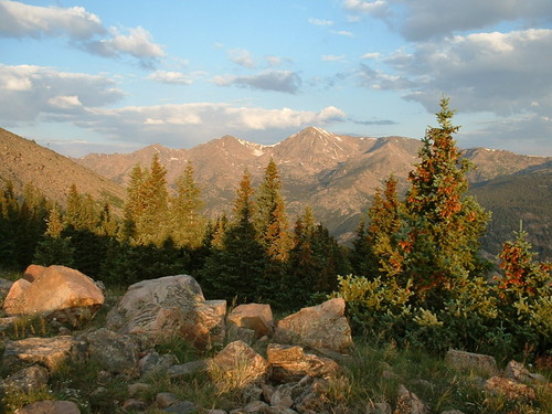
Mount Jackson at sunrise.
Indeed, as we made our final descent to the East Cross Creek (10,670 feet), we saw many tents set up. This is where we had planned to spend the night, but were happy now that we did not have to carry all the extra camping gear along with us.
We continued across the creek on some slippery rocks and logs. Shortly thereafter we caught up with a group of two guys, two girls and a dog. We would cross paths a number of times but they eventually beat us to the top.
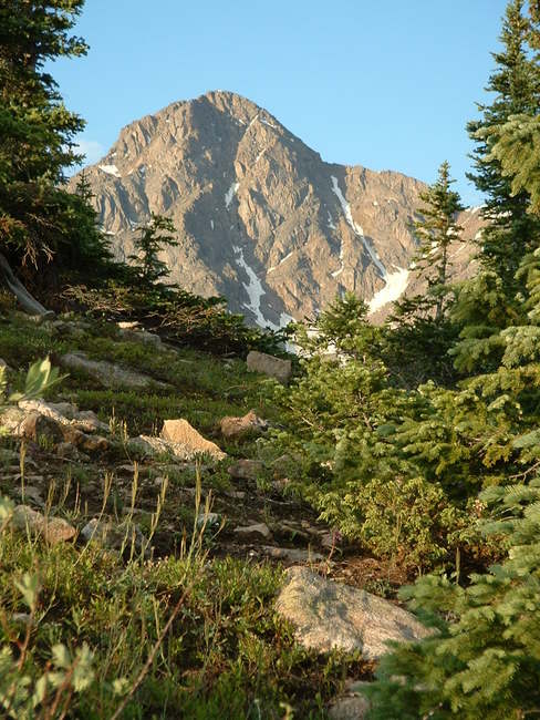
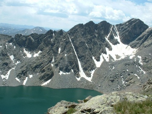
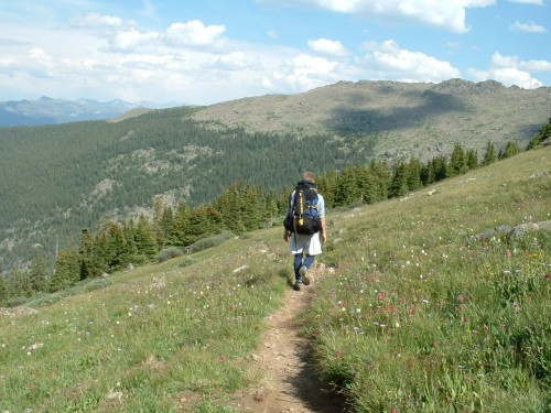
First glimpses of the prize
The steeper climbing began as we started up the north side of the North Ridge. The trail was good, but we had to take frequent breaks to get some water and catch our breaths. The weather was warm and I stripped down to my short sleeves for comfort.
7:55 AM- Arthur and I finally reached timberline at 11,700 feet. The trail continued uphill with steep switchbacks, becoming more and more rocky until rocks were all that were between us and the summit. Lots of rocks, in fact. Before long we were working our way across a gargantuan field of talus, led by impressive cairns, and, eventually, views of the summit itself. As we crested the ridge, we found excellent views of the valley below, with Lake Patricia and several other small lakes and ponds. And rising above it all was the northeast side of Mount of the Holy Cross, including the steep Angelica Couloir.
We kept going up, up, and up, until we started leveling out for a long walk along a line of snow at the top of the northeast ridge. During this time we passed and were passed by several other hikers, and eventually we made it to the end of the line of snow and the gentle slope. Here we found ourselves 600 feet below the summit, but with a much steeper slope of talus and little hope of finding a steady trail to follow. We pretty much climbed straight up, taking many more breaks along the way to give our lungs some rest.
10:30 AM- Five hours into our hike, we reached the 14,005-foot summit of Mount of the Holy Cross. There were a handful of people on the top, but not as many as I had expected. Signing the register, I was surprised to be only the tenth of the day to sign in atop this grand mountain.
The views from the summit of Mount of the Holy Cross were undeniably impressive. To the north you could see the jagged Gore Range; immediately to the southwest was Halo Ridge and its impressive string of rocky summits; peeking over the steep cliffs to the south an incredible view of the deep blue "Bowl of Tears" opened up; and the fourteeners of several surrounding ranges were visible, though not quite so apparent because of a haze hanging in the air. On top of that, I walked over to the head of the Holy Cross Couloir and peered down the steep slope, though I couldn't really see anything except the ground thousands of feet below.
Arthur and I caught our breath and inhaled some packs of trail mix, along with some water and an energy drink I had brought along. The crowd was increasing on the mountaintop, and it was apparent the main herd of the day was yet to come, as we could see a steady string of climbers coming up from the north slopes.
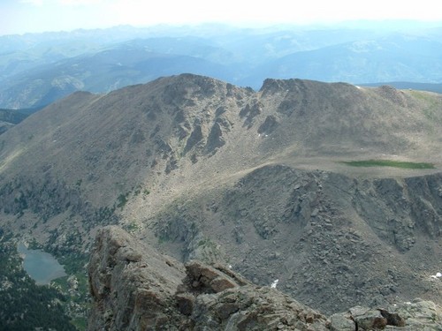
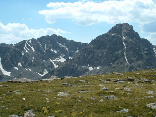
Notch Mountain
11:10 AM-With our eyes to the skies, Arthur and I left the summit of Mount of the Holy Cross and descended to the saddle of talus and snow which lay between that mountain and its neighboring "centennial thirteener," Point 13,831, also known as "Holy Cross Ridge." We wanted to take this route over Holy Cross Ridge and Halo Ridge, as the slopes appeared far less crowded and the scenery was guaranteed to be fantastic.
Even as we approached the saddle, one lone hiker did pass us from this direction, and we stopped to ask him a couple questions about the route. He assured us the hike was a nice one, as long as we did not continue on to Notch Mountain. That is, unless we were prepared for some class 4+ climbing. Today we were not. He also told us to be sure to watch the clouds to the west, for there was no escaping the exposure to the weather once we were caught on the three miles of Halo Ridge.
"Holy Cross Ridge"
The slope leading up to Point 13,831 was very similar to the slope leading up to Mount of the Holy Cross, only not as long. We were also afforded great views down into the "Teardrop Route" leading to Bowl of Tears, and some of the cliffs we looked down over were startlingly captivating.
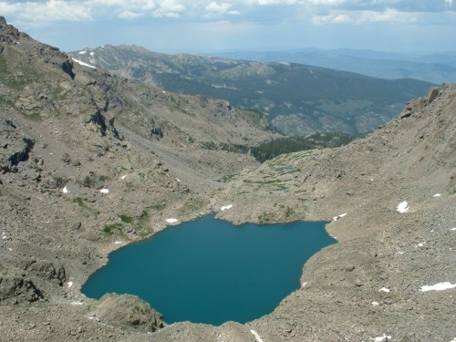
12:12 PM- Alas we came to the top of Holy Cross Ridge, and the new views we had were breathtaking. The spectacular Tuhare Lakes appeared below us (to the south), both brilliant-blue and above timberline, connected by a long waterfall pouring over a huge slab of rock. Their backdrop included Point 13,768 and the 13,271-foot Whitney Peak. Also, the views of Mount of the Holy Cross and of the rest of Halo Ridge were great to experience.
Tuhare Lake and unnamed peak from summit of "Holy Cross Ridge"
Arthur and I were the only ones on this summit for a short time, until three other guys came up from the southwest side of the slope, panting and relieved to have made it to the top. Once again we gleaned information from them and told them what we had just experienced on the North Ridge Route. Even as we were speaking a few snow flurries fell. We continued to watch the weather but none of the clouds seemed to be developing into anything substantial. This was the critical decision-point of whether to press on to the unforgiving Halo Ridge.
And, after about a 15 minute rest at the summit, Arthur and I did press on, headed east to Point 13,373. After descending a long, gentle slope of talus, Arthur and I came to a rather flat area that had a mix of grass and rocks. Eventually getting across this, the ridge began to narrow, allowing great views to the east and to the west, as we began our short ascent to the next summit.
1:30 PM- Point 13,373 is not an officially-ranked summit, but it was an impressive one nonetheless, with steep towers and cliffs forming it's east side. It fit in perfectly with the rough ridge-line connecting to the two mountains we had already traversed.
We stayed at its summit only a few minutes before finding our way down the east side of its talus and boulder-filled slope. It was a fairly steep descent, and we had to go around a rather large notch, which seems to be a normal occurrence on Halo Ridge.
As we continued across the next rough saddle, we came as close to the Bowl of Tears as we would on this climb, so I snapped several pictures of it. The skies were holding back wonderfully, and it was becoming quite hot. What a beautiful day!
Bowl of Tears
The gradually-rising ridge-top we continued along was interspersed with Alps-like grassy hills and typical Rocky Mountain. . . rocks. It was becoming somewhat tiring to our legs, feet and brains, trying to pick out all our footsteps as we went. Arthur had long-since developed a headache, probably due at least in part to the high elevation we had been at for so long.
This continued on for some time, and as we neared the next summit, we began to get a view of the famous "Holy Cross Couloir" for which the Mount of the Holy Cross is named. 2:51 PM- Finally we reached the summit of an officially-ranked peak, Colorado's 441st highest mountain, Point 13,248. This was nothing more than a huge pile of rocks, which we walked over just as we had been doing for many hours previous.
Our destination, oddly enough, was a small shelter which we had been getting closer and closer to as we circled Halo Ridge. Now past our final summit of the day, the shelter came into view once again and we approached it with wearying bodies.
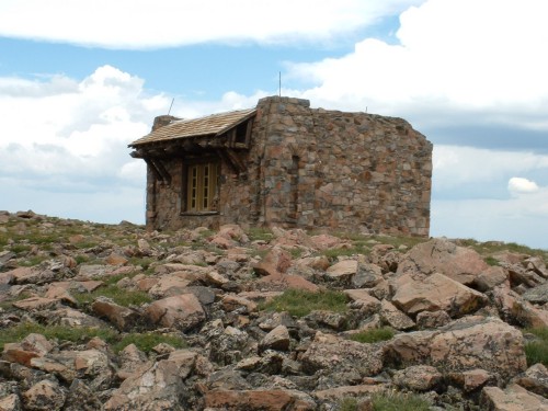
Notch Mountain Shelter
3:13 PM- We made it to Notch Mountain Shelter, a small but very sturdily-built hut made of solid rock. Arthur and I sauntered on in and sat at the also-sturdy picnic table inside. That was the only thing in the cement-floored building, except for a vacant fireplace and a window, through which we had an excellent view of the Holy Cross Couloir.
The main thing on our minds at the moment was food, so we got to eating ravenously. A brave marmot ventured inside to say hello (and beg for some food), but he eventually went away after he decided we were too hungry to share.
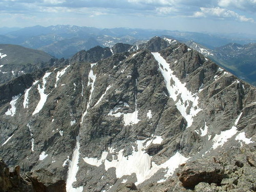
After adequately stuffing ourselves, Arthur and I returned outside and admired the ridge we had just traversed. What a place! I took several photos of the Holy Cross, as well as Halo Ridge and the surrounding scenery, before we departed.
Holy Cross
3:40 PM- Two large cairns showed us the way to the very nice trail which we would take the rest of the way out of the mountain. Arthur and I walked back and forth down the very-well made switchbacks, quickly losing elevation as we went. At one point we had a good view of Notch Mountain, which we would certainly not get to today.
Eventually our surroundings turned from talus to grass, and then from grass to shrubbery, but we were still well above timberline. At one point two quail, an adult and a young one, scurried away as we walked by, and I got a picture of them as well.
4:30 PM- We had been above timberline for eight and a half hours, and now we at last returned to the shade of the spruce forests. Granted, the trees were small and straggly at first, but it at least gave us a sense that we were getting somewhere.
Timberline!
However, we were still very far from the trailhead. We continued farther and farther into the valley, and the great thing about this part of the hike was the abundance of wildflowers. Once we were past them, however, the trail became a long and monotonous path through the woods. At least it was very easy walking the rest of the way. No more talus or boulder-hopping.
Eventually we met up with the Fall Creek Trail and followed this long stretch for a long time through endless spruce forest. This trail was generally a gradual downhill, but there were uphill stints and areas of flat walking as well.
5:45- After 12 1/4 hours, 15 miles and a vertical mile of hiking, we finally came back to our starting point, completing our loop at the Halfmoon Trailhead.
Conclusion: This mountain experience included my ninth 14er, Arthur's first mountain ever, magnificent scenery which cannot be explained, just seen. . . and beautiful weather to go along with it. I would say of the hikes I have done in Colorado so far, this takes the new number one spot as my favorite. The Holy Cross Wilderness abounds with beauty and it seems there is always more to be explored. Just get off the main trails and it seems you can get away from the crowds; we did not see a single soul the last several hours of our hike, after having seen dozens of people crowding the north slope of Mount of the Holy Cross.
In a nutshell, this was an outdoor adventure I will not soon forget, and I can't wait for my next opportunity to explore some more of the great Colorado outdoors!