When the sunshine I was driving through started to turn into a big cloud of snow, this idea changed pretty quickly. I drove up the long, winding dirt road, past the Fourmile Creek trailhead and up to the four wheel drive parking spot. Two other vehicles were there, both getting ready to leave the mountain. The road at this point was actually covered in a layer of fresh snow, and the snow was still falling. Along with the cold whipping winds, I had a feeling this hike was going to be a doozy.
Mount Sheridan
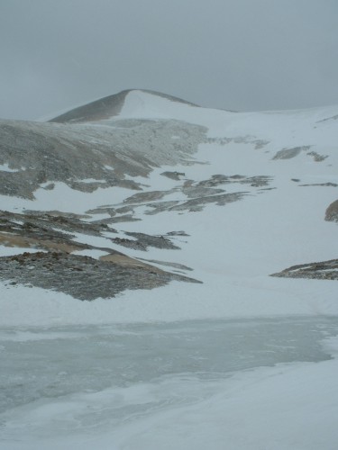
9:52- I started up the remainder of the rough gravel road to the decrepit buildings of the Hilltop Mine. At one point I took my gloves off to reach in my pack to get the map. As soon as I lay them down, the wind shot them away, and in a matter of seconds they were hundreds of yards from me. In the strong winds and chilly temperature, not having my gloves was not an option, so I took off after them. They had already blown across a small frozen pond and up the other snowcovered bank. I made my way over to them, retrieved them, and then went on with getting out my map. Apparently I looked at it wrong, because several minutes later I realized I was heading up the wrong mountain.
At this point, it really made no sense to turn around and head down and back up to get to Mount Sherman. Instead, I continued on my current course up the rocky east face of Mount Sheridan. The farther uphill I went, the more windy it got, and by the time I made it to Mount Sheridan’s summit, I could no longer even stand up without fearing being blown off the side of the mountain.
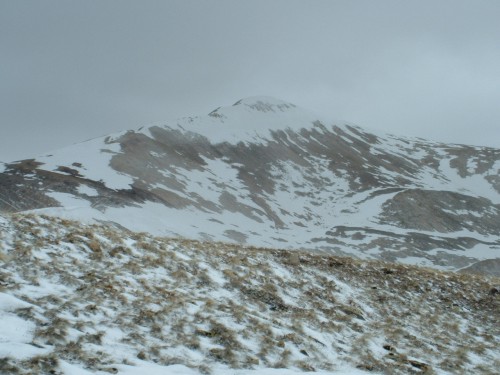
Mount Sherman
11:20- I reached the 13,748 foot summit of Mount Sheridan, and could scarcely get my video camera out of the pack to tape the event. The wind was so horrible I just needed to get away, almost as soon as I had arrived. At least by this point the snow had finally stopped falling, and I could actually feel the sunshine on my back. Even with the sun, however, I had to move pretty quickly to stay warm as the winds continued to get more and more harsh. I was starting to feel tingling in my limbs and face, especially.
I continued downhill on the northeast side of Mount Sheridan to the saddle between it and Mount Sherman. As I continued up the other side of the saddle onto the southeast ridge of Mount Sherman, I found some relief from the wind by stopping every couple minutes and lying on the ground. Still, I was finding it nearly impossible to keep warm, for I had not prepared for these conditions.
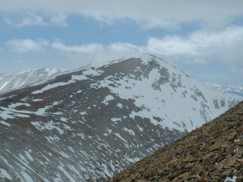
Horseshoe Mountain
Before long, however, I followed the cairns to the crest of the ridge, where the trail headed up toward the summit of Mount Sherman. I was, for lack of a better word, stunned by the wall of wind I came against at this point. It had to be hurricane force. I took a deep breath and ran several steps forward and fell to the ground to escape being blown away. I lay there panting, and still found no relief from the wind. Several more times I inched my way forward on all fours, but I felt there was no way to keep myself warm, and it seemed the risk was getting greater with every move I took.
12:10- As I lay there catching my breath once again with the wind searing through me, I looked up at the summit and saw the fast-moving clouds and steady whips of snow blowing from the peak. It looked possibly even worse than where I currently was laying. And though I was so close, I felt it was too risky to go any further. Besides all this, the batteries in my digital camera went dead before I was able to get any post-snow pictures, and I had mistakenly bought AAA instead of AA batteries earlier this morning. Leaving the summit of Mount Sherman for another day, I finally made the wise decision to turn around and head back to my jeep.
As I started back down to the saddle, I tried to find a shortcut down to the mine, but was met with a humongous snow field with a steep dropoff below. I think there was a shortcut there somewhere on the north side of the saddle, but I missed it. Instead, I continued across the saddle and then cut my way across the snowfield where the saddle met the front of Mount Sheridan. From there I cut downhill toward the mines, and the lower I got the less severe the wind was. What a nice Memorial Day it was, everywhere but on the tops of those mountains!
3:02- I arrived back at my parking spot, relieved to have escaped the wind’s furies, even though I was not able to accomplish my goal for the day. Still, I was able to reach the summit of Mount Sheridan, the 126th highest peak in the state, and I learned a good bit more of the topography of the area.
Today turned out to be four hours of driving and three hours of hiking. Once again, I learned that you must be prepared for anything in the mountains of Colorado. I will not be under-dressed again! Also, I will henceforth remember to keep a good grip on my gloves, especially in windy conditions, and I will make sure I get the right batteries for my camera. However, I think the most important lesson I have learned is: When it is time to go no further, turn around! I am glad I did today.